Nuclear attack was a constant boogeyman of the Cold War.
In the 1950s and 1960s especially, American citizenry was encouraged to be proactive in protecting themselves from nuclear fallout (remember “Duck and Cover”?).
Arlington was no exception. In late 1960s, the Northern Virginia Regional Planning Commission, which covered the cities of Alexandria, Fairfax and Falls Church and Arlington, Fairfax, Loudon and Prince William Counties, developed a civil defense plan for a possible nuclear attack. These plans included a fallout shelter program, mapping shelters in regard to population centers and how to get people to those shelters.
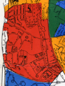
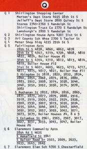
The Northern Virginia Region Community Shelter Program, published in 1968, outlined these plans and processes, and also published maps of shelter locations for subsets of the region. The Arlington Edition of the map sectioned the county into color-coded zones so users could find a shelter in their area and contained tips on creating and stocking your own shelter. The above image shows the fallout shelter locations for Shirlington, and the image below lists the names of these shelters. The map itself has the following introduction:
“In case of danger from fallout from a nuclear attack upon this country, you and your family would need to know WHERE TO GO and WHAT TO DO. This Community Shelter Plan contains this information for every citizen. It is based on making the best possible use of the fallout protection now available. If you and your family take action, as this Plan recommends, you will have maximum chance for survival from fallout effects.”

What about you?
Did you have a fallout shelter in your home or neighborhood? Do you remember preparing for “the Big One”? We want to hear from you.

 To make an appointment:


