• Skip to primary navigation
  • Skip to main content
  • Skip to primary sidebar
  • Skip to footer
Home - Arlington County Virginia - Logo
MENUMENU
  • Join Now
  • My Account
    • Login
    • My Checkouts
    • My Holds
    • My Lists
    • My Reading History
    • About Borrowing
    • About Holds
    • About My Account
  • Hours & Locations
    • All Hours & Locations
    • Holiday Closings
  • News
    • Library News
    • Director's Blog
    • Get Email Updates
  • Contact Us

Arlington Public Library

MENUMENU
  • Search
  • Collections
  • Library Services
  • Events
  • Community Engagement
  • Join Now
  • My Account
    • Login
    • About Borrowing
    • About Holds
    • About My Account
  • Hours & Locations
    • All Hours & Locations
    • Holiday Closings
  • News
    • Library Blog
    • Get Email Updates
  • Contact Us

Stormy Weather

Post Published: March 11, 2008

Georgetown waterfront

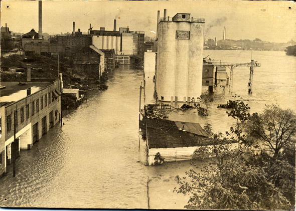
The photo above is of an unidentified industrial area of Arlington flooded by the Potomac River.

If you look carefully, you can see the Washington Monument in the distance. The photograph is dated from the mid-20th century, and the Virginia Room is looking for more information about this photograph.

We have an answer! Alert readers emailed the Virginia Room to let us know that this area is in fact Georgetown, near the Key Bridge. The silos belong to the Washington Flour Company. Thank you for your help!


What About You?

Do you know anything about this area of Arlington? Do you remember the Potomac flooding? What about other floods in Arlington? Please let us know!


March 11, 2008 by Web Editor

Reader Interactions

Comments

  1. Anonymous says

    November 21, 2011 at 5:10 PM

    This is not Arlington, this is Georgetown. I am sure it was taken from Key Bridge, before the Whitehurst Freeway was built in 1949.

  2. The Librarians says

    November 22, 2011 at 11:29 AM

    You are correct – The silos belong to the Washington Flour Company, and were located in Georgetown. Here's another photo of the Washington Flour Company, not from our collection. Thanks to everyone who emailed with more info!

Primary Sidebar


Charlie Clark Center for Local History: Where Stories Live


Photo of President Lyndon B. Johnson shaking hands with Martin Luther King, Jr., at the signing of the Voting Rights Act of 1965. Photograph by Yoichi Okamoto. Courtesy of the Lyndon B. Johnson Library.

The Voting Rights Act of 1965: Remarks by Rev. Dr. DeLishia A. Davis


Photo of the historical marker for suffragist Mary Morris Lockwood, located at 1501 North Lincoln Street, across Hayes Park in Arlington, VA.

Arlington, VA Suffragist Mary Morris Lockwood


Link to blog post.

Remembering Kitty Clark Stevenson


Link to blog post.

Appreciating Arlington Educator Katherine Mosley Ross


Read more blog posts from the Center for Local History


Charlie Clark Center for Local History


The Charlie Clark Center for Local History (CCCLH) collects, preserves, and shares resources that illustrate Arlington County’s history, diversity and communities. Librarians and archivists develop collections of unique research material and make them available for use by residents, students, teachers, genealogists, scholars, authors, journalists and anyone interested in learning more about Arlington County.

Footer

About Us

  • Mission & Vision
  • Charlie Clark Center for Local History
  • News Room
  • Get Email Updates

Administration

  • Policies
  • Library Staff
  • Job Opportunities
  • Propose a Program or Partnership

Support Your Library

  • Friends of the Library
  • Giving Opportunities
  • Donating Materials
  • Volunteer Opportunities

Our Mission

We champion the power of stories, information and ideas.

We create space for culture and connection.

We embrace inclusion and diverse points of view.


Download the Library App

Download the Library App

Arlington County | Terms & Conditions | Accessibility | Site Map
· Copyright © 2025 Arlington County Government ·