• Skip to primary navigation
  • Skip to main content
  • Skip to primary sidebar
  • Skip to footer

Alert

Central Library parking garage closed & book donations paused for the Fall Book Sale More Info

Home - Arlington County Virginia - Logo
MENUMENU
  • Join Now
  • My Account
    • Login
    • My Checkouts
    • My Holds
    • My Lists
    • My Reading History
    • About Borrowing
    • About Holds
    • About My Account
  • Hours & Locations
    • All Hours & Locations
    • Holiday Closings
  • News
    • Library News
    • Director's Blog
    • Get Email Updates
  • Contact Us

Arlington Public Library

MENUMENU
  • Search
  • Collections
  • Library Services
  • Events
  • Community Engagement
  • Join Now
  • My Account
    • Login
    • About Borrowing
    • About Holds
    • About My Account
  • Hours & Locations
    • All Hours & Locations
    • Holiday Closings
  • News
    • Library Blog
    • Get Email Updates
  • Contact Us

Update: Quincy St entrance closed during upgrades at Central Library.

Center for Local History Blog

Dedicated to collecting, preserving and sharing the history of the community.

At the Movies

Post Published: June 5, 2007

The Buckingham Theatre

A far cry from the multiplex theaters of today, the Buckingham Theatre greeted its customers with a façade that more closely resembled a Colonial-style mansion.

Built by the developers of the Buckingham Community in 1939, The Buckingham, as it was known, was the central part of a small shopping center located at the intersection of Glebe Road and Pershing Drive. The building itself was considered to be quite a creative endeavor due to the classic front design which eschewed the usual marquee, neon lighting, and signs that were common to other theaters of its time.

The Buckingham played a role in the desegregation movement in Arlington when it was the site of demonstrations against Virginia's Massive Resistance policies in July 1962. Those arrested were eventually acquitted of all charges.

After a successful run of 47 years, the theater closed in 1986 and was converted to a post office in 1990, which it remains to this day.

What about you?

Do you have any memories of the Buckingham Theatre? Let us know what you remember!
June 5, 2007 by Web Editor

Look Out for Spy Hill

Post Published: May 22, 2007

Spy Hill

The area known as Spy Hill may not be the largest neighborhood in Arlington, but it certainly can claim to have had a unique history.

Spy Hill was originally comprised of two land grants, the Thomas Pearson grant of 1707 (660 acres), and the John Ball grant in 1742 (166 acres). The Pearson property was leased in 1740 for clearing and cultivation while the Ball property, which included the log cabin erected by John Ball known as the Ball-Sellers house, was sold as small lots around 1835. Together, these two areas became known as Boulevard Manor.

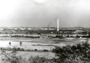
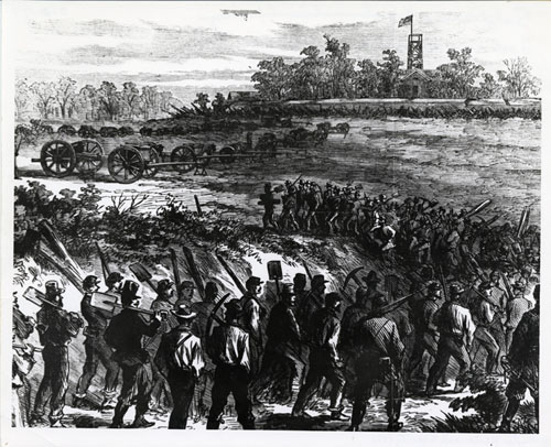
In 1851, New York farmer Timothy Bishop Munson and his family moved to Fairfax County. Munson started a nursery and raised sheep on the land known as Munson’s Hill, now part of present day Arlington, which included the greater portion of Boulevard Manor. During the Civil War, Confederate forces established an outpost on Upton’s Hill where the regional park is now located, from which they could observe troop movements across the Potomac. When the Confederate army withdrew from this area, the Federal army established Fort Upton on Upton’s Hill as part of the defense of Washington owing to the ability to see the Washington Monument and the Capitol from this vantage point. The areas of Boulevard Manor and Fort Upton received the name Spy Hill as a result of these activities. The image above is a Harper’s Weekly sketch of Union troops on Spy Hill.

In the 1860s, William A. Torreyson purchased land from the Carlin and Munson estates, including a sizeable portion of Munson’s Hill, and established a dairy farm. Torreyson’s daughter Lucy married George Reeves in 1894 and they took over the dairy farm in 1902, the last to operate in Arlington, until closing in 1955 under the ownership of George Reeves’ son, Nelson. After its sale in the late 1970s, Spy Hill was a popular gathering place for teenagers until its eventual development in 1990.

What about you?
Do you have any memories of the Spy Hill neighborhood? Let us know what you remember!

May 22, 2007 by Web Editor

The Wilson School

Post Published: May 15, 2007

1117032-0157Starting in 1902, residents of the Fort Myer Heights area clamored for a school to serve their area. The School Board seemed to agree, but the project itself never seemed to get going. There were serious problems with the construction of other schools in the Arlington area (at that point part of Alexandria County), and the board did not want another headache. Eventually, what was originally known as the "Clarendon" school and then Fort Myer School was built on Wilson Boulevard in 1910, approximately where the first tee of the original Washington Golf & Country Club golf course was placed.
In 1926, school administrators sent letters to Woodrow Wilson's widow, Edith, informing her of the school's name change to Woodrow Wilson School, in honor of the late president. These letters, a photograph of the school's construction, and two photographs of the first classes at the school are in the Community Archives' collection on the public schools. The photograph above, taken in 1932 for a fire insurance survey, shows the 1926 addition and can be found in the County Manager's Library Collection.

Wilson School became empty with the construction of Francis Scott Key School in 1968. It now houses the Mongolian School, a cultural education center for the Mongolian community in Arlington (one of the largest in the nation), and holds community events. There is hope that the Wilson School can become an organized arts center for the entire community.


What About You?
Did you go to Wilson or used the building for other events? Let us know what you remember!


May 15, 2007 by Web Editor

When Cows Were Local

Post Published: May 8, 2007

Dairy farming in Arlington? Why yes, Virginia, there once was such a thing. In fact, Arlington was home to a number of dairy farms in years past, with one of the best known being the Reeves farm.

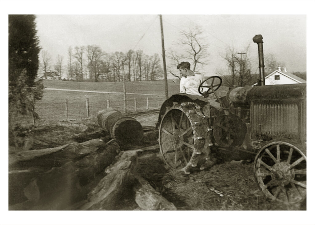
Photo of George Reed moving logs in 1949 on the Reeves farm.

Photo of George Reed moving logs in 1949 on the Reeves farm (note the different last name, which could be a typo or just a different generation with a last name change through marriage).

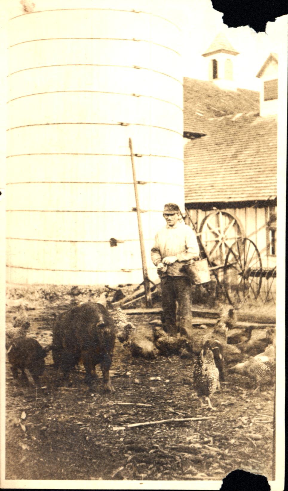
George Reeves feeding some chickens, no date

George Reeves feeding chickens, no date.

Purchased in 1866 as a 160-acre farm by William H. Torreyson, the property stretched west of Four Mile Run and south of Wilson Boulevard, extending beyond Route 50 to Glen Carlyn Road. The farm was later operated by Torreyson's daughter, Lucy, and her husband George Reeves from 1898-1949; their son Nelson Reeves was made a partner in 1924. Nelson and his wife, Louise, kept the farm in operation until its final shipment of milk in July 1955 marked the end of dairy farming in Arlington.

The Reeves family continued to reside on the property, gradually selling off land as the county's population grew. After Nelson Reeves passed away in 2000 at the age of 90, ten members of his family sought to have the farmhouse preserved, eventually resulting in its designation as a historic district. Shown in the photograph above, Reevesland, as it is now known, provides a unique link to Arlington's agricultural heritage, and preserves a valuable family legacy for present day residents to enjoy and appreciate

What About You?
Do you have any recollections regarding the Reeves farm or other dairies in Arlington? Let us know what you remember!

Listen to the 2011 WAMU story on Reeves farm.

May 8, 2007 by Web Editor

Wartime Housing

Post Published: May 1, 2007

J.E.B. Stuart Homes

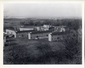
The J.E.B. Stuart homes were one of several federally funded projects that built low-cost WWII housing with a minimum of amenities.

Built in the southern part of the county, they were constructed without regard to Arlington County building and zoning regulations. Segregated according to race, as was the custom at that time, the George Pickett, Shirley, J.E.B. Stuart and Jubal Early homes were for whites. The George Washington Carver and Paul Dunbar home were for blacks. The homes were built on concrete slabs without basements and heated by coal stoves. Tenants were selected on the basis of need. Residents of the Stuart homes, pictured above, and the other developments were for people employed by the rapidly-growing federal government during the war years; Arlington County in general had a significant upsurge in population during the 1930s and 1940s.

After the war, those who could afford to moved out of the homes and the properties gradually deteriorated. The federal government wanted to dispose of the projects and offered them to the County to be used for low income families living in sub-standard housing. However, the County decided against the offer as acceptance would have entailed the establishment of a local Housing Authority, a proposal which was very controversial at the time. As a result, the homes that had been built to a higher, more permanent standard were sold to tenants and the others were razed.


What About You?

Do you remember the J.E.B. Stuart homes and similar housing? What were the war years like in Arlington? Let us know what you remember!


May 1, 2007 by Web Editor

Arlington’s Hoover Airport

Post Published: April 17, 2007

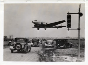
Whenever the subject of air travel or airports in Arlington is raised, it is perhaps inevitable that talk of National Airport will dominate any discussion. A glance through decades past, however, reveals the interesting story of Hoover Airport, Arlington’s first airfield.

Located in a pasture at the south end of the 14th Street Bridge on land now chiefly occupied by the Pentagon, Hoover Airport opened in 1926. Curiously enough, the following year saw another airport, Washington Airport, open virtually next door to Hoover on grounds previously housing a race track and horse show. After four years, the two combined services and became a single enterprise operating under the name Hoover Airport.

Diminutive even by 1930 standards, Hoover Airport had a single 2,400 foot runway which was intersected at mid-point by a road which had to be chained off by guards when the aircraft were landing or taking off. As advances were rapidly being made in the field of aviation, the shortcomings of Hoover Airport soon became apparent. In 1938, ground was broken at Gravelly Point, located at the Potomac’s edge where the Abingdon estate had been, and by 1941, Washington National Airport was open for business and Hoover Airport was no more.


What About You?

What are your memories regarding air travel from and to Arlington? Let us know what you remember!


April 17, 2007 by Web Editor

Mystery Door

Post Published: April 10, 2007

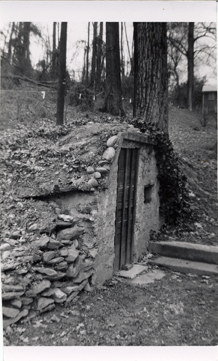
Do you recognize this scene?

Mystery door

This photograph was taken by Eleanor Lee Templeman, author of "Northern Virginia Heritage" and "Arlington Heritage," which tell the story of our area's development through the 1950s.

This photo was not used in either book, but was part of her donation of photographs to the Community Archives. It may be the door to a springhouse or cold food storage area.

What About You?

Do you recognize this door, or this area? The Virginia Room could use your help. Let us know what you remember!


Do you have a question about this story, or a personal experience to share? 

Use this form to send a message to the Charlie Clark Center for Local History.

Center For Local History - Blog Post Message Form

Do you have a question about this story, or a personal experience to share? Use this form to send a message to the Center for Local History.

"*" indicates required fields

This field is for validation purposes and should be left unchanged.

Share Your Story

April 10, 2007 by Web Editor Tagged With: local history news

Everyone’s National Pastime

Post Published: March 27, 2007

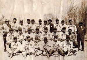
Around this time each year, the cry of “Play Ball!” heralds the start of another season of baseball.

While the Washington Senators, Baltimore Orioles, and now the Washington Nationals dominate most local discussions concerning America’s Pastime, there is a fascinating, if unheralded, aspect of baseball that took root decades ago in Arlington’s African-American community. The earliest team, dating back to 1910, the Old Virginia Blues, played each Sunday on a field in East Arlington near Arlington Junction.

The two best known teams, the Virginia White Sox and the Green Valley Black Sox, started playing ball in the 1930’s and helped to provide a gathering place for local residents and families to socialize. Starting around May 30th of each year, weekends would see teams competing at a ball field situated near High View Park, on land which is now occupied by the Virginia Hospital Center, near George Mason Drive and Lee Highway. After the land was purchased for development, the teams folded, lacking a place to play.


What About You?

Did you have a family member, or, perhaps know anyone that played for the Virginia White Sox or the Green Valley Black Sox? Let us know what you remember!


March 27, 2007 by Web Editor

Arlington Goes Green

Post Published: March 20, 2007

In 1900, Congress transferred 400 acres of land along the Potomac near Ft. Myer to the Department of Agriculture in order to create an experimental farm for plant testing and the improvement of plants and methods of cultivation.

The area had been neglected for many years and even the top soil had been taken for the National Cemetery. Over the years a number of interesting activities and experiments took place at the farm:

  • Americans on governmental or private missions abroad were encouraged to send foreign plants home to see if they would help improve domestic plants. The farm naturalized over 100,000 types of foreign plants for domestic use; soybeans are one of the best known crops to be introduced this way.
  • When a plant disease threatened to wipe out the domestic sugarcane industry in the 1920s, the Farm led the way in developing immunity to this blight which ultimately resulted in the rebuilding of the sugarcane industry.
  • One of the more unusual examples of the Farm’s experiments involved grasses for golf greens. Before WWI the country’s golf courses were almost entirely dependent on German grown seed for their grasses. When the supply was cut off by the war, golf courses throughout the country contributed funds for experiments at Arlington to develop new domestic varieties.


With the development of Arlington National Cemetery and the construction of Memorial Bridge there was pressure to relocate the farm.

In 1932 much of the farm’s work was shifted to Beltsville, MD, and by 1941 the remainder of the property had been transferred to the War Department for use in the National Defense Program.


What About You?

Do you recall the Arlington experimental farm? Let us know what you remember!


March 20, 2007 by Web Editor

Home of the Sir Loiner

Post Published: March 13, 2007

Topps matchbook both ways

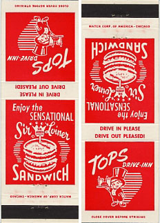
Arlington has never had a shortage of unique local eateries and for many, one of the most memorable was the Tops Drive Inn on Lee Highway.

Home of the "Sir Loiner," a double-decker hamburger thought by many to be a forerunner of today's Big Mac, Tops was founded by businessman James J. Matthews in 1953.

The original Tops Drive Inn was a 15-seat facility which included a team of carhops and a machine called the Teletray, enabling drivers to order their food without getting out of the car. The interior featured turquoise-colored phones at the tables for placing your order, and mini-juke boxes for hearing the hits of the day. There were 18 Tops in the DC Metro area before Matthews merged the chain into Gino's Inc. in 1968.

Some Tops trivia:

  • Three of the sandwiches served at Tops were the Sir Loiner, the Jim Dandy, and the Maverick.
  • Tops was the original server of Col. Sanders' Kentucky Fried Chicken in the area, and owner James J. Matthews served on the board of Kentucky Fried Chicken Corporation after Colonel Sanders retired.
  • There was once a 15 minute television afternoon weather show sponsored by Tops called "Top Of De Vedder." The program was hosted by "Professor Felix Von Topsnak," who used a hand-drawn map of the U.S. on which he'd chart the weather while dressed in an overcoat, top hat and monocle.


What About You?

Were you a Tops regular? What was your favorite thing on the menu? Let us know what you remember!

Use this form to send a message to the Center for Local History.

Center For Local History - Blog Post Message Form

Do you have a question about this story, or a personal experience to share? Use this form to send a message to the Center for Local History.

"*" indicates required fields

This field is for validation purposes and should be left unchanged.

Share Your Story

March 13, 2007 by Web Editor

  • « Go to Previous Page
  • Page 1
  • Interim pages omitted …
  • Page 30
  • Page 31
  • Page 32
  • Page 33
  • Page 34
  • Interim pages omitted …
  • Page 36
  • Go to Next Page »

Primary Sidebar

News

Collage of four bookmark contest design finalists marking America's 250th anniversary.

Vote for Your Favorite Bookmark Designs

To mark the 250th anniversary of the United States … ... about Vote for Your Favorite Bookmark Designs

Read More News
See More Service Updates

Center for Local History

Large banner that reads, “Let there Be Peace on Earth” displayed near the Pentagon following the 9/11 terrorist attacks. Photo credit Diane Kresh. Charlie Clark Center for Local History, 133-01-02-01-130

Resilience and Community

September 11, 2001 "When terrorists slammed into … ... about Resilience and Community

Read More Local History

Director’s Blog

An American flag is draped over a portion of the Pentagon near where the structure was hit by a plane during the 9/11 attack. Photo credit Diane Kresh. Charlie Clark center for Local History, 133-01-02-01-107

On the 25th Anniversary of September 11

"Never Forget." When I hear that phrase today, … ... about On the 25th Anniversary of September 11

More Director's Blog

Footer

About Us

  • Mission & Vision
  • Charlie Clark Center for Local History
  • News Room
  • Get Email Updates

Administration

  • Policies
  • Library Staff
  • Job Opportunities
  • Propose a Program or Partnership

Support Your Library

  • Friends of the Library
  • Giving Opportunities
  • Donating Materials
  • Volunteer Opportunities

Our Mission

We champion the power of stories, information and ideas.

We create space for culture and connection.

We embrace inclusion and diverse points of view.


Download the Library App

Download the Library App

Arlington County | Terms & Conditions | Accessibility | Site Map
· Copyright © 2026 Arlington County Government ·