Newly-Digitized Postcards Share a Glimpse of Bygone Virginia…
The Center for Local History has recently added two groups of early and mid-twentieth century postcards to our online collection.
 Virginia in Postcards contains 80 postcards from the Eastman-Fenwick Family Papers and the personal postcard collection of Diane Salman. These have been digitized, both front and back (or recto and verso, as archivists sometimes call them) for a total of 160 images.
The first collection (Record Group 306) contains the personal postcards of Diane Salman, and consists of many postcards collected by her grandmother, Irene Andris Finlayson. Finlayson lived most of her life in Morgantown, West Virginia and died in 1954.
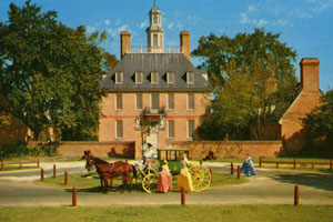
This collection is particularly interesting as it includes many paintings and lithographs of historical Virginia sites including the Royal Governor’s Palace in Williamsburg and the George Washington Masonic National Memorial in Alexandria.
Many also include handwritten messages (mostly from the 1910s) such as:
“Suppose you have heard from [?] that Frank and I are married. Write to me…”
The second collection of postcards (Record Group 60) from the Eastman-Fenwick Family collection are primarily from the 1950s, 1960s and 1970s.
These postcards are part of a much larger collection of personal papers and ephemera from four generations of two prominent Arlington families. Unlike the Salman collection, the Eastman-Fenwick postcards were not mailed but simply collected. They include striking photographs such as a locomotive charging through Ford, Virginia, and a large turkey farm in Highland County.
This project was completed with generous help from volunteers Peter Perry, Levertes Ragland, Sharad Shah, Cattleya Concepcion, and Justin Paulhamus.